 50 Years Surveying in Papua New Guinea
 50 Years Surveying in Papua New Guinea
 50 Years Surveying in Papua New Guinea
 50 Years Surveying in Papua New Guinea
 50 Years Surveying in Papua New Guinea
 50 Years Surveying in Papua New Guinea
 50 Years Surveying in Papua New Guinea
 50 Years Surveying in Papua New Guinea
 50 Years Surveying in Papua New Guinea
 50 Years Surveying in Papua New Guinea
 50 Years Surveying in Papua New Guinea
Services
TECHNOLOGY:
The head office operates GeoComp, Terra-Model, 12d and CivilCad software applications for surveying and engineering projects, Auto-Cad 2013 is utilised for drafting and presentation purposes, Mapinfo, Arc View and ER Map-per are used for GIS projects, Reliance and WinPrism for GPS control surveys and Micro-Soft office suites for general office administration. The company has 11 desktop computers, printers, 16 laptops, AO wide-format printer and an AO Digitiser.
GNSS Receivers - 5x Leica GS15 GNSS Leica Viva Dual Frequency and RTK GPS units with Spectrum Planning software / 4x Sokkia Dual Frequency GPS Receivers for field data obser-vations and Trimble Geomatics Office software / 6x Garmin handheld GPS units.
2 X Viva TS, TS12 and TS15 Robotic TS. 4 X Flex Line, 2 x TS06, 2x TS09, And 4 x TC1205.
Levels - 3x Digital and 5x Automatic Levels.
The data reduction, plan preparation and final output are completed for all projects in Port Moresby or on site where this is required. The office operates both Geocomp and Civilcad software for surveying and engineering projects, AutoCAD 2013 is utilised for drafting, MapInfo is engaged for GIS projects, Reliance for GPS surveys for GIS, Winprism for GPS control surveys, and various other office software is available for office management. We have upgrades from Geocomp soft ware to Terramodel software.
Surveys conducted:
• Cadastral
• Mining & Petroleum
Exploration
• Hydrographic
• GPS & GIS
• Lidar Imaginary
• Geodetic
• Topographic Surveys<
• Precision Engineering & Construction set out
• Mobile Laser Scanning
RESOURCES AND CAPACITY
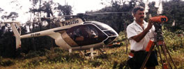
Our survey teams are under the control of experienced Registered and Engineering Surveyors, all equipped with GPS RTK and static units, electronic Total Stations, laptop computers and printers for surveys away from Port Moresby.
The data reduction, plan preparation and final output are completed for all projects in Port Moresby or on site where this is required. The office operates both Geocomp and Civilcad software for surveying and engineering projects, AutoCAD 2013 is utilised for drafting, MapInfo is engaged for GIS projects, Reliance for GPS surveys for GIS, Winprism for GPS control surveys, and various other office software is available for office management. We have upgrades from Geocomp soft ware to Terramodel software.